Matthew 11 (WEB)
Possible Site of Bethsaida
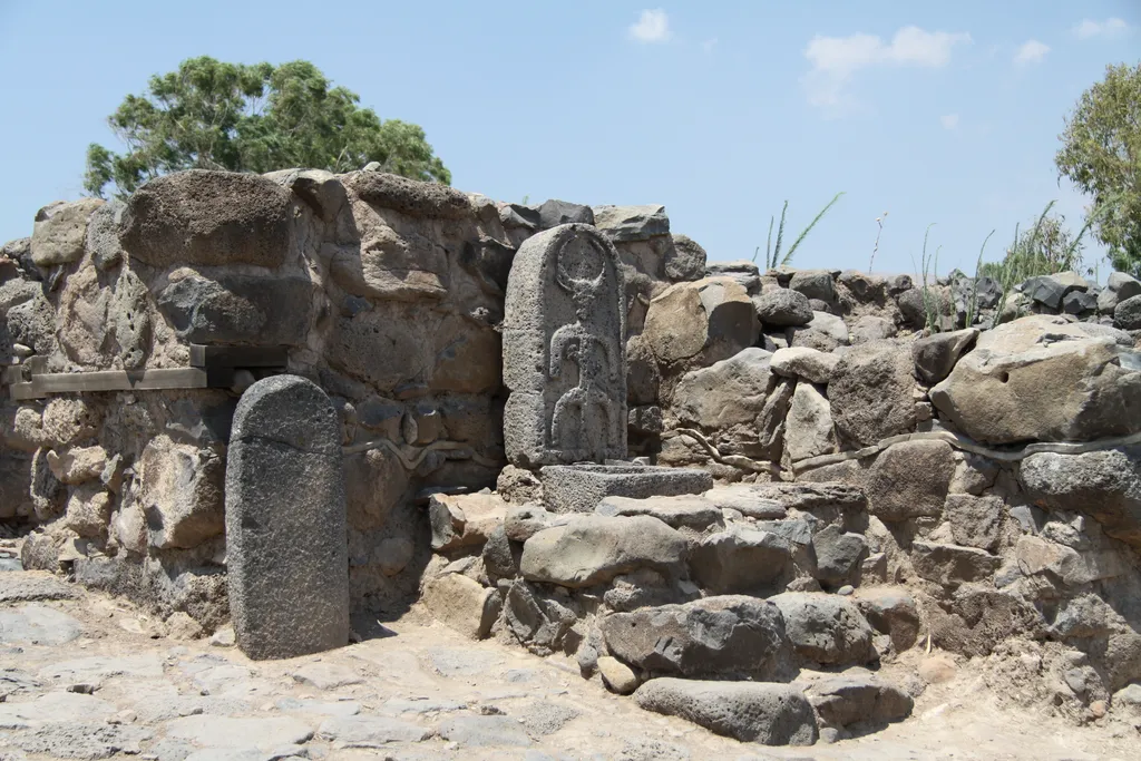
The town of Bethsaida is mentioned several times in the Gospels, and is found in each one at least once. In fact, the area between Bethsaida and Capernaum is where the majority of Jesus’ activities in Galilee took place. Here in John’s account, Bethsaida is said to be where Philip, Andrew and Peter were from (although it seems Peter moved to Capernaum at some point). In Mark’s Gospel, Jesus visits the city and heals a blind man (Mark 8:22-26), while in Matthew and Luke’s account, Jesus includes Bethsaida in His “woes” (along with Chorazin and Capernaum – Matt. 11:21, Luke 10:13).
The location of the city is to this day not known with certainty. The historical record does narrow the locality down somewhat. The Jewish historian Josephus says that Bethsaida was in the territory of Philip the Tetrarch and that he renamed the town Julias, after the wife of the emperor Augustus (and mother of Tiberias), and raised its status from village to city.1 Josephus also says that the Jordan “passes by” Bethsaida-Julius.2 Since Philip’s territory was east of the Jordan River, this puts Bethsaida on or near the East bank of the river. Theodosius, writing around A. D. 530, says that Bethsaida was six miles from Capernaum, and that the headwaters of the Jordan River was fifty miles from Bethsaida.3 This suggests that the site of the town was not far from where the Jordan empties into the Sea of Galilee. The proximity of Bethsaida to the lake is also suggested by the name of the city itself, which means “place of the fishers” in Aramaic.4 Thus two sites are identified as the most likely locations of Bethsaida: Khirbet el-Araj and et-Tell. Roman pottery has been found on the surface at both sites, confirming habitation during Jesus’ life, and both are geographically located near where the historical record says they should be.
Khirbet el-Araj is located only about fifty yards from the shore of the Sea of Galilee on the current West bank of the Jordan River. Although it is on the wrong side of the river today, this was not necessarily the case two thousand years ago, as the Jordan at this spot has changed its course many times. Gottlieb Schumacher, citing the difficulty of et-Tell’s distance from the Sea of Galilee proposed Khirbet el-Araj as the true site of Bethsaida. Although Byzantine-era artifacts have been found at the site, archaeological surveys using ground penetrating RADAR have shown that there is nothing but sand below the Byzantine layer, strongly suggesting that there was no village here during Jesus’ ministry. However, Mendel Nun, an acknowledged expert on the Sea of Galilee, has argued that the level of the Sea of Galilee was actually lower than it is today in ancient times, and therefore much of the Khirbet el-Araj site is under water.
et-Tell is about 1.2 miles from the lake on a rocky hill on the East side of the Jordan. As the name (the Mound) suggests, the site’s original name has been lost even to the locals. Although it was identified as Bethsaida by Edward Robinson in 1838, it has only been excavated since 1990 by the Consortium of the Bethsaida Excavations Project (BEP), led by Rami Arav, Richard A. Freund and John F. Shroder, Jr. and hosted by the University of Nebraska, Omaha. The site itself covers twenty acres, making it the largest archaeological site on the Sea of Galilee. They have identified et-Tell as the ancient capital of the kingdom of Geshur, perhaps called Tzer or Tzed (Josh 19:35).5 The city was therefore one of the most important cities of the Iron Age. In the ninth century B.C. it was surrounded by a nearly twenty-foot-thick wall and featured the largest biblical era gate found in Israel.6 Archaeologists found the remains of several Hellenistic courtyard type houses, inside which they found fishing net weights and needles for repairing nets, iron anchors and fish hooks.7 In another house an almost intact wine cellar was discovered. The cellar contained several wine amphorae and vine pruning hooks, leading archaeologists to the conclusion that the house belonged to a vintner.8
One of the most interesting finds was a Roman-era temple, which the BEP argues may have been built to commemorate Philip’s renaming the city after Julia. The temple follows the typical plan of Roman temples, having a columned porch, a hallway leading to a long, narrow “holy of holies,” and a rear porch. An incense shovel and several religious figurines were also found near the temple.9 Archaeologists also found decorated stones near the temple that are almost identical to stones found in the Chorazim synagogue, leading them to argue that the Chorazim stones were actually taken from the et-Tell site (they are only about three miles apart).
Although the BEP did find limestone containers, suggesting the presence of Jews in the city, the population of et-Tell was most likely almost totally gentile.10 Limestone was used exclusively by Jews for food storage due to stone’s ability to remain ritually pure, as opposed to clay pottery.
As mentioned before, a major problem with identifying et-Tell as ancient Bethsaida is et-Tell’s distance from the Sea of Galilee. However John Shroder, a geological expert and member of the BEP, examined geological maps of the area and concluded that the current shoreline of the Sea is “not necessarily the ancient shoreline.”11 Shroder argues that et-Tell sits on a very active fault line, the level of the lake is constantly changing, and that the mouth of the northern branch of the Jordan River has built up a delta where it flows into the Sea of Galilee. Thus, the site of et-Tell may very well have been near the shore in Jesus’ time.12 Other examples of this phenomenon include Ephesus, once on the shore of the Aegean, but now about six miles from the sea.
Subsequent geological investigation has lent credibility to Shroder’s argument. At the base of et-Tell sedimentary clay containing crustacean microorganisms was discovered. Further, large boulders and gravel cover the clay. Carbon 14 tests were conducted on organic material underneath this layer of boulders and gravel revealed a date range of A.D. 68-375. Shroder theorizes the cataclysmic earthquake of A.D. 363 caused a large landslide to flow across the plain where et-Tell is located, “cutting Bethsaida off from the shore.”13 After the city was cut off from the shore the city was abandoned by the fourth century. It appears Jesus’ condemnation of Bethsaida came to pass, as the city was so quickly forgotten that Byzantine pilgrims (who have been shown to be fairly accurate in their identifications of biblical sites) could not find the site, and some of them misidentified the Khirbet el-Araj site as ancient Bethsaida.
Associate photos “John 1_44 Fig 1-Bethsaida Overview,” “John 1_44 Fig 2-Bethsaida Aerial,” “John 1_44 Fig 3-Plan of Bethsaida,” “John 1_44 Fig 4-Fish net weight Bethsaida,” “John 1_44 Fig 5-Incense Shovel from et-Tell,” “John 1_44 Fig 6-Jewish Limestone pot handle,” “John 1_44 Fig 7-Diagram Showing the Shifting Shore of Galilee.”
Josephus, Antiquities, 18.2.1.28 ↩︎
Josephus, Wars, 3.10.7.515 ↩︎
Theodosius, de situ terrae sancte, ed, Geyer, ()138. ↩︎
Jack Finegan, The Archaeology of the New Testament: The Life of Jesus and the Beginning of the Early Church, (Princeton, NJ: Princeton University Press, 1992) 114. ↩︎
Rami Arav, “Toward a Comprehensive History of Geshur” pages 1-48 in Bethsaida: A City By the North Shore of the Sea of Galilee, Vol. 3, ed. by Rami Arav and Richard A. Freund (Kirksville, MO: Truman State University Press, 2004) 1. ↩︎
Israel Ministry of Foreign Affairs, “Bethsaida: An Ancient Fishing Village on the shore of the Sea of Galilee.” Online: http://www.mfa.gov.il/MFA/History/Early History - Archaeology/Bethsaida- An Ancient Fishing Village on the shore (accessed March 11, 2010). ↩︎
Mendel Nun has challenged the identification of these artefacts as fishing implements, while the BEP says that some of the artefacts initially found were misidentified, many more fishing artefacts have subsequently been found. See Steven Feldman, “The Case for el-Araj” Biblical Archaeology Review, Vol. 26, No.1 (Jan/Feb 2000). ↩︎
Israel Ministry of Foreign Affairs, “Bethsaida: An Ancient Fishing Village on the shore of the Sea of Galilee.” Online: http://www.mfa.gov.il/MFA/History/Early History - Archaeology/Bethsaida- An Ancient Fishing Village on the shore (accessed March 11, 2010). ↩︎
Rami Arav, Richard A. Freund, and John F. Shroder, Jr., “Bethsaida Rediscovered.” Biblical Archaeology Review, Vol.26, No. 1 (Jan/Feb 2000): 44-51, 53-56. ↩︎
Mark Appold, “Peter in Profile: From Bethsaida to Rome,” pages 133-148 in Bethsaida: A City By the North Shore of the Sea of Galilee, Vol. 3, ed. by Rami Arav and Richard A. Freund (Kirksville, MO: Truman State University Press, 2004) 142 ↩︎
Rami Arav, Richard A. Freund, and John F. Shroder, Jr., “Bethsaida Rediscovered.” Biblical Archaeology Review, Vol.26, No. 1 (Jan/Feb 2000): 44-51, 53-56. ↩︎
Rami Arav, Richard A. Freund, and John F. Shroder, Jr., “Bethsaida Rediscovered.” Biblical Archaeology Review, Vol.26, No. 1 (Jan/Feb 2000): 44-51, 53-56. ↩︎
Rami Arav, Richard A. Freund, and John F. Shroder, Jr., “Bethsaida Rediscovered.” Biblical Archaeology Review, Vol.26, No. 1 (Jan/Feb 2000): 44-51, 53-56. ↩︎
1When Jesus had finished directing his twelve disciples, he departed from there to teach and preach in their cities.
2Now when John heard in the prison the works of Christ, he sent two of his disciples 3and said to him, “Are you he who comes, or should we look for another?”
4Jesus answered them, “Go and tell John the things which you hear and see: 5the blind receive their sight, the lame walk, the lepers are cleansed, the deaf hear, the dead are raised up, and the poor have good news preached to them. 6Blessed is he who finds no occasion for stumbling in me.”
7As these went their way, Jesus began to say to the multitudes concerning John, “What did you go out into the wilderness to see? A reed shaken by the wind? 8But what did you go out to see? A man in soft clothing? Behold, those who wear soft clothing are in kings’ houses. 9But why did you go out? To see a prophet? Yes, I tell you, and much more than a prophet. 10For this is he, of whom it is written, ‘Behold, I send my messenger before your face, who will prepare your way before you.’ 11Most certainly I tell you, among those who are born of women there has not arisen anyone greater than John the Baptizer; yet he who is least in the Kingdom of Heaven is greater than he. 12From the days of John the Baptizer until now, the Kingdom of Heaven suffers violence, and the violent take it by force. 13For all the prophets and the law prophesied until John. 14If you are willing to receive it, this is Elijah, who is to come. 15He who has ears to hear, let him hear.
16“But to what shall I compare this generation? It is like children sitting in the marketplaces, who call to their companions 17and say, ‘We played the flute for you, and you didn’t dance. We mourned for you, and you didn’t lament.’ 18For John came neither eating nor drinking, and they say, ‘He has a demon.’ 19The Son of Man came eating and drinking, and they say, ‘Behold, a gluttonous man and a drunkard, a friend of tax collectors and sinners!’ But wisdom is justified by her children.”
20Then he began to denounce the cities in which most of his mighty works had been done, because they didn’t repent. 21“Woe to you, Chorazin! Woe to you, Bethsaida! For if the mighty works had been done in Tyre and Sidon which were done in you, they would have repented long ago in sackcloth and ashes. 22But I tell you, it will be more tolerable for Tyre and Sidon on the day of judgment than for you. 23You, Capernaum, who are exalted to heaven, you will go down to Hades. For if the mighty works had been done in Sodom which were done in you, it would have remained until today. 24But I tell you that it will be more tolerable for the land of Sodom on the day of judgment, than for you.”
25At that time, Jesus answered, “I thank you, Father, Lord of heaven and earth, that you hid these things from the wise and understanding, and revealed them to infants. 26Yes, Father, for so it was well-pleasing in your sight. 27All things have been delivered to me by my Father. No one knows the Son, except the Father; neither does anyone know the Father, except the Son and he to whom the Son desires to reveal him.
28“Come to me, all you who labor and are heavily burdened, and I will give you rest. 29Take my yoke upon you and learn from me, for I am gentle and humble in heart; and you will find rest for your souls. 30For my yoke is easy, and my burden is light.”